Posts

Showing posts from May, 2024

LIVE BLOG: Severe Weather Expected Today (May 25, 2024) Across Kansas, Oklahoma, and North Texas
Image
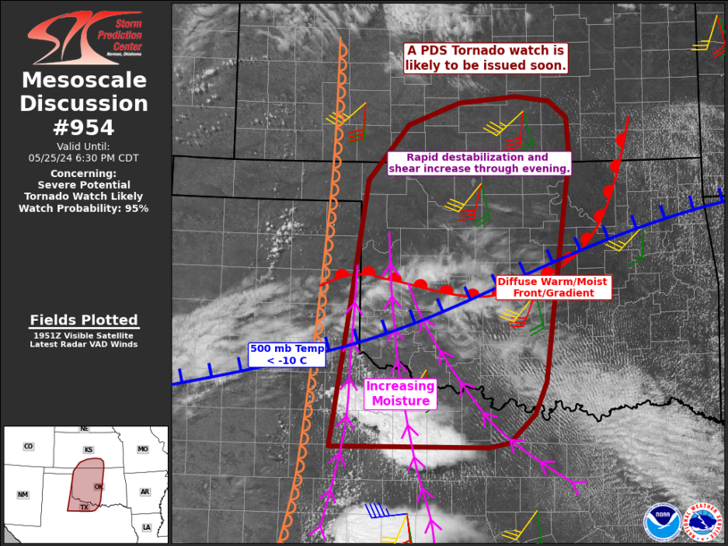
3:10 PM CDT UPDATE - A PDS (Particularly Dangerous Situation) Tornado Watch will be issued soon for Western/Central Oklahoma and adjacent parts of Northwest Texas and Southern Kansas. 12:30 PM CDT UPDATE - The SPC has made some changes to the risk areas with their most recent update, mostly to expand the higher risk probabilities farther south and east. 7:30 AM CDT UPDATE - I am going to be busy today and will not be able to update frequently until this evening, but I wanted to get a couple posts up this morning. There are a few things to mention. The SPC expanded the higher end severe probabilities into North Texas, which is what I was explaining in last night's discussion - that North Texans WILL see a higher risk of Severe Weather this afternoon and evening. The Moderate Risk will likely be extended into far NW/N TX with the Enhanced Risk pushed into the DFW metro. No High Risk has been issued yet for the region, but I feel one will be coming in the next ...

Tornado Outbreak Likely Across Kansas, Oklahoma, and North Texas on Saturday, May 25, 2024

Image
 11:30 PM CDT | May 24, 2024 - It is going to be a very volatile weather day across the Great Plains. Confidence in widespread Severe Weather, some of which will be significant, is high. The SPC Day 2 Outlook which was issued after midday states that Several strong to violent tornadoes, extreme hail, and corridors of widespread wind damage are forecast over parts of the central and southern Plains from late Saturday afternoon into the night. This is very strong wording and they go on to say that "Only reduced confidence in total storm coverage is precluding a High Risk at this time". You can see their official outlook below. Looking at the latest guidance, I believe that the difference with storm coverage among the models is that some are picking up on a disturbance in the jet that moves into Northwest Texas during the afternoon. As this disturbance approaches, it would likely trigger development after 3:00 PM from western North Texas through Southwest Oklahoma. Additional de...

2024/05/23 - Severe Weather Live Blog - May 23, 2024

Image
8:45 PM CDT UPDATE - Cycling Tornadic Supercell cluster in far Southwest Oklahoma collapsed the activity farther north. When thunderstorms are intense, they create their own environment. Subsidence on the backside was too much for the other cells to sustain themselves, despite the favorable environment. A Tornado Watch remains until 11:00 PM, but I would not be surprised to see many Texas counties removed and potentially those on the northern fringe in Oklahoma, near I-40. Significant redevelopment appears unlikely, in my opinion. Focus will be on the existing activity. 7:20 PM CDT UPDATE - Most intense supercell has been located just west of Altius this evening. There is a large, extremely dangerous Tornado on the ground as of the writing of this post. This is a capture of the latest radar. Note, it does NOT update.   3:55 PM CDT UPDATE - Widely scattered storms will continue to develop off the dryline over the next 2-3 hours. The most favorable conditions for Severe W...

2024/05/23 - Evolution Of Today's Storms Becoming Clearer

Image
9:30 AM CDT | May 23, 2024 - Last night, a cluster of storms unexpectedly developed in South Central Oklahoma. Not surprising, they had a little help... You can see repeated radar pulses firing into the area before and during development. The purpose of this, in my opinion, was to send an outflow boundary southward to back winds more toward the southeast today across Oklahoma. This morning, the radar has been pulsing out of Cannon AFB in eastern New Mexico. The frequency has been aimed toward the Texas Panhandle/NW TX and Western OK. This would be to charge the atmosphere where storms are expected to develop late this afternoon off the dryline. You can also see evidence of the frequency pulses with the "gravity waves" in the area. These are the ripples/breaks in the cloud cover that remain stationary in the SE TX Panhandle/NW TX, despite the clouds moving. Watch the loop and see for yourself. The Storm Prediction Center has a Slight Risk for much of the state today and into t...

2024/05/22 - Severe Weather Again Tomorrow & Especially Saturday

Image
 10:50 PM CDT | May 22, 2024 - The deep moisture that is in Texas will lift northward in response to an approaching trough. Dew points in the 70*F's will reach the I-40 corridor around midday on Thursday. The environment across Oklahoma tomorrow afternoon and evening will be supportive of supercells capable of Quarter to Baseball-size Hail, Damaging Winds, and a few Tornadoes. The uncertainty and possible fly in the ointment for a localized outbreak is a disturbance expected to move through Texas. This will trigger showers and storms as early 11:00 AM or 12:00 PM south of the Red River. This activity could create an area of subsidence to the north that would suppress our storm chances tomorrow afternoon. Unfortunately, we will not know until things start to unfold. Worth noting is that, yet again, I did not see any chemtrails in the sky today to the west of OKC. My prediction for the next outlook is that they will upgrade parts of the state to a Hail-driven 30% Enhanced Risk, most ...

2024/05/22 - Hailers Developing In West Central Oklahoma

Image
5:40 AM CDT | May 22, 2024 - Right on schedule and where they had been frequency pulsing off and on for FOUR hours Monday morning... Convection has developed a long I-40 in West Central Oklahoma. This activity is already likely producing pea to dime-size hail and larger is expected as storms mature. North of the boundary, Large Hail will be the main hazard with a low Damaging Wind threat. Along and south of the boundary, all hazards will be possible.

2024/05/21 - Severe Weather Expected Through Memorial Day Weekend

Image
 3:00 PM CDT | May 21, 2024 - Busy, busy, busy! We have a dryline that is moving through Central Oklahoma this afternoon. A very unstable environment exists along/ahead of this boundary. Expect storms to zipper down the boundary between 4:00 and 6:00 PM. Supercells capable of all hazards will be possible. The boundary will slosh back toward the west with the loss of daytime heating, but a cool front will be moving through North Central Oklahoma as well. This boundary will merge with the retreating dryline near I-40 after dark. A second disturbance will arrive from the west late tonight/tomorrow morning. This is where the forecast gets "fun" as some models show the boundary stalling/lifting back just north of the I-40 corridor overnight in response to height falls from the west. Other models show the boundary continuing to slowly sink southward. Why is this crucial? Because activity is expected to develop during the predawn hours. The risk for Severe Weather will increase prio...

2024/05/20 - May 19, 2024 Severe Weather Not Totally Natural???

Image
4:00 PM CDT | May 20, 2024 - The May 19th Severe Weather Not Totally Natural??? In the following video, I break down what I feel are more than coincidences with what unfolded. Just how much of our weather is natural?

2024/05/19 - Live Blog: Potentially Significant Severe Weather Possible Into Tonight

Image
  LIVE BLOG 9:17 PM CDT UPDATE - Supercell with a history of producing Tornadoes is moving toward the western OKC Metro. Dangerous situation. 4:53 PM CDT UPDATE - There are two severe storms near the TX/OK border. The northernmost cell is what is referred to as a left-moving supercell. The greater severe/tornado risk is going to be with the southernmost cell as it tracks eastward into far Western Oklahoma. Mature supercells with strong updraft rotation will have the potential to track more toward the E/SE. With that in mind, the I-40 corridor needs to monitor. 3:10 PM CDT UPDATE - PDS Severe Thunderstorm Watch is in effect until 10 PM for parts of Northwest Oklahoma. All hazards are expected across the watch area. Damaging Winds of 60-90 MPH will be the primary hazard, followed by Hail from the size of Quarters to Softballs, and a few Tornadoes. The Damaging Wind threat will be greatest in Kansas, while the Tornado Risk will be greatest in Oklahoma, where cells will be ...

2024/05/19 - Early Morning Weather Update

Image
7:15 AM CDT | May 19, 2024 - I wanted to discuss in more detail early this morning about what I had posted last night. The last two posts were heavily focused on the geo-engineering aspect of the weather. From jet spraying to radar frequency beams. Multiple radar sites in the region have been producing significant arrays, not related to radar detection. The following is an illustration of where I have seen frequent pulsing from the various sites since yesterday. This serves to "charge" the atmosphere ahead of severe weather through ionization. I go back to the fact that the radar sites went through a significant upgrade in the early-2010's with the dual polarization capability. Sites would be down for weeks at a time to physically install upgrades. Anyway... no jet spraying was seen last night where I live, west of OKC. No chemtrails as of this morning either. They typically spray to lay a grid and often kill storms that would track near I-40 and toward OKC. In the above ...

2024/05/19 - I Will Explain Later This Morning, Good Night

Image
 1:25 AM CDT | May 19, 2024 - I checked to see what the SPC had for their Day 1 Outlook, and I noticed something related to the last post... I will explain later this morning. It's important. Good night, all.

2024/05/18 - Late Evening Update On Tomorrow's Severe Risk

 10:40 PM CDT | May 18, 2024 - Not much to report on tonight... the latest model guidance is arriving and confidence in at least a couple supercells in Northwest Oklahoma late tomorrow afternoon and evening has increased. The previous update appears in good shape. Worth noting however is that there have been no chemtrails spotted in the skies as of this evening, to the west of Oklahoma City. The last event (May 15th), which was a non-event for most of the area - chemtrails were noted the evening before and morning of the (non) event. The particulates that are sprayed into the sky are used to create a grid. In most cases, they use it to kill convection trying to develop or use it to hamper daytime heating. Both were used for the May 15th non-event as widespread (artificial) cloud cover helped keep temps a few degrees below what was needed to break the cap. The cells that did develop were evaporating and cloud ripples could be seen as a result of the frequency pulsing. Radar pulsing ...

2024/05/18 - Severe Weather Possible Tomorrow, May 19th

Image
 7:10 AM CDT | May 18, 2024 - Severe Weather is possible late tomorrow afternoon and evening, especially in Northwestern Oklahoma. A very warm, moist environment will exist east of a dryline Sunday afternoon. A capping inversion will be in place, but a piece of energy that is breaking from an offshore low will move into the region toward sunset on Sunday. The strength and timing of this energy will be pivotal to just how many storms can punch through the cap late in the day. Surface heating will weaken the cap, but the extra "umph" from this energy is what will break it. It is now moving onshore southern California and will be partially sampled by the weather balloons for new model data later this morning. It will be fully sampled with this evening's balloon launches. I have illustrated my thoughts on where the greatest risk of Severe Weather appears to be in the graphic below. Across the Enhanced Risk area, storm chances appear to be in the 40-60% range with 20-30% in th...

2024/05/15 - Live Blog: Severe Weather Possible Into Tonight

Image
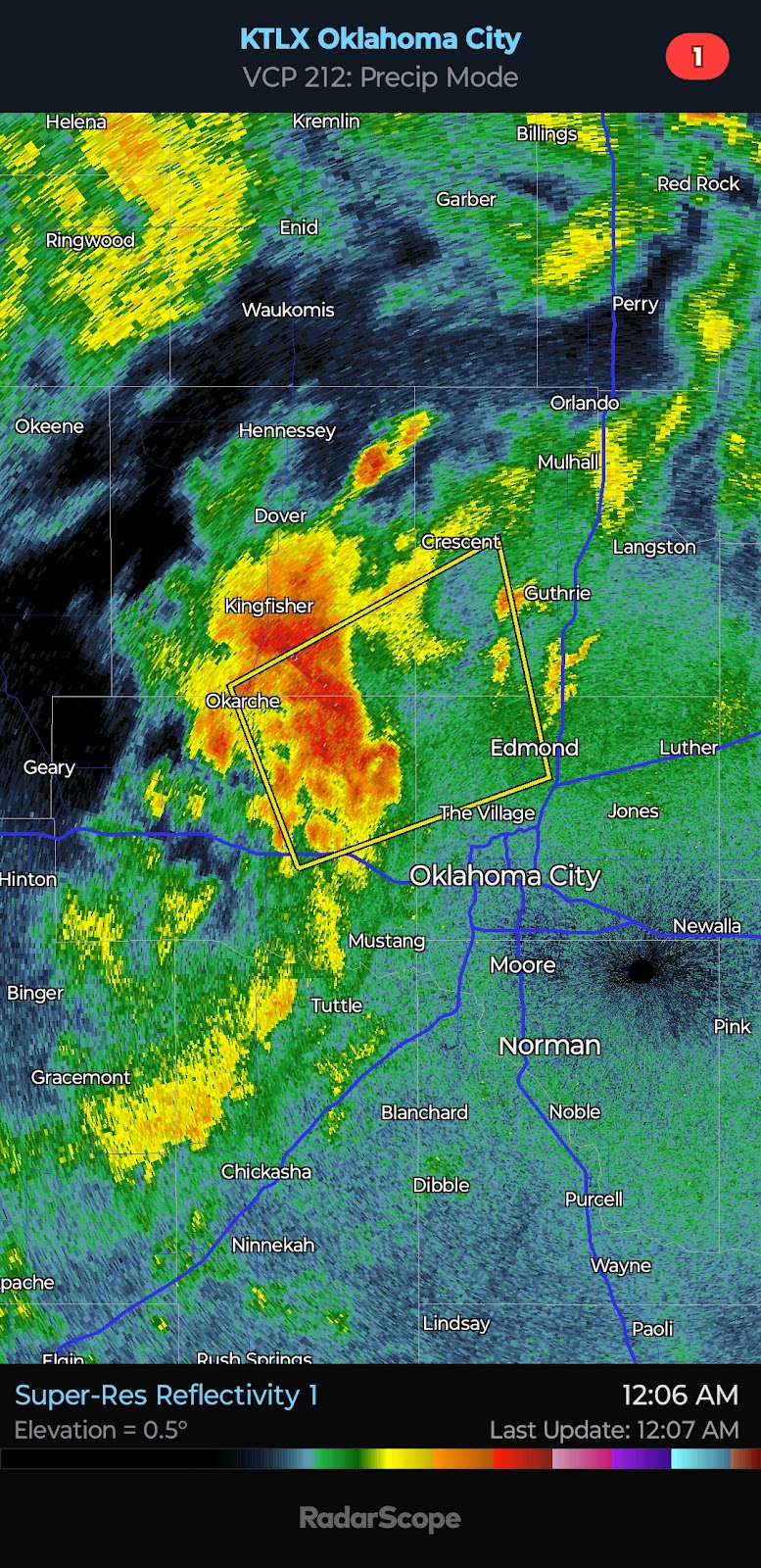
 12:07 AM CDT UPDATE - Weather engineering was apparent today between jet spraying and radar frequency pulsing... The intent appeared to be for at least a delay in activity along I-40 (potentially impacting OKC) until late evening to reduce the severity. As mentioned in the morning update, though, the enhanced risk has set up in the vicinity of the I-40/44 corridors with a severe storm approaching Piendmont/NW OKC and eventually Guthrie and Edmond. 4:50 PM CDT UPDATE - On the Amarillo WSR-88D Radar, you can see two distinct beams. The first is directed toward a supercell in the northwest TX Panhandle, and the second is directed in the opposite direction toward a supercell in the southeast TX Panhandle. Not surprising, the cells intensified shortly after the frequency pulse was seen. The radar system has that capability, and to the naked eye and those not "in the know" - it would appear as feedback or a glitch. It is not.

2024/05/15 - Enhanced Risk Of Severe Weather Today

Image
 10:15 AM CDT | May 15, 2024 - There is an Enhanced Risk of Severe Weather for portions of Oklahoma from late afternoon into tonight. I have attached the official SPC Day 1 Outlook, which was issued around 8 AM this morning below. Following it, I have posted my thoughts as well as a couple graphics to illustrate when/where I believe the risk of Severe Weather will be. Scattered storms are expected to develop across the Texas & Oklahoma Panhandles into far Western Oklahoma during the 3:00 to 5:00 PM time-frame. Additional storms may also fire near the Oklahoma/Kansas border. Activity will shift toward the east and northeast. Damaging Winds of 60-70 mph will be likely with the strongest of storms with Quarter to Golf Ball-size Hail and even a Tornado or two possible. The Tornado Risk will be greatest in Northern Oklahoma and far Southern Kansas. As we get into the mid-evening hours, the low-level jet will be ramping up... Supercells and multicells will be transitioning into storm...

2024/05/13 - Severe Risk Returns Wednesday, May 15, 2024

Image
 9:15 PM CDT | May 13, 2024 - A wetter but disorganized weather pattern will continue. The risk for Severe Weather will increase by Wednesday afternoon. A weak surface low is forecast to develop in Northern Oklahoma with a frontal boundary/wind shift trailing it. Compressional warming near the boundary, coupled with southwesterly winds, will result in temperatures peaking in the upper-80*F's to lower-90*F's across Northwest/Western Oklahoma. Widely scattered storms will fire in the very warm environment. Forecast soundings suggest that Damaging Winds of 60-65 mph will be the primary hazard, followed by Quarter to Half Dollar-size Hail. The Tornado Risk appears VERY low. Shear is not expected to be very strong which is unusual for this time of year, and it will serve to keep the severe risk on the lower end of the spectrum. A lower end severe risk will exist on Thursday, but it is too early to outline any areas. A weather pattern more typical of May is likely to return by next w...

2024/05/06 - LIVE BLOG: Severe Weather Outbreak Today

Image
  LIVE BLOG 6:50 PM CDT UPDATE -  Several Supercells are ongoing in Northwest Oklahoma right now. Additional storms have recently developed near and to the south of Elk City. The risk for Strong/Violent Tornadoes continues to increase early this evening. I am especially concerned with the southern flank of the Supercell cluster as cells will have uninhibited access to the moist, unstable environment in place to the south and east. Whether this southern flank tracks right along the I-40 corridor or perhaps just north, remains to be seen. The risk for Significant Severe Weather continues across the entire PDS Tornado Watch area. 3:40 PM CDT UPDATE -  Strong to Severe Storms are ongoing from NW OK through WC KS... Additional cells are trying to develop in the SE TX Panhandle and far SW OK. Activity is currently lifting NE but will turn more toward the east as updraft rotation increases. The southern area that is highlighted in yellow would pose the greatest risk to the I-40 ...

2024/05/05 - Preliminary Severe Weather Timing & Risk Level For Monday, May 6, 2024

Image
 10:30 PM CDT | May 5, 2024 - I have some thoughts to share on the Severe Weather Outbreak that is expected tomorrow. I am going to start with the official outlook from the Storm Prediction Center shows, followed by a comparable event many will remember, and then my own preliminary timing and risk level of the severe weather. The Storm Prediction Center has a Moderate Risk in place for a good portion of Oklahoma tomorrow with the following headline: " Numerous severe thunderstorms are expected to develop and move eastward Monday afternoon through Monday night across parts of the southern/central Plains. Multiple strong/potentially long-track tornadoes, very large to giant hail, and severe/damaging winds all appear likely." I like to take a look at analog events because history is our best teacher. One very similar event, in regards to the system track and anticipated environment is May 24, 2011. You can view historical graphics here: https://www.spc.noaa.gov/exper/archive/eve...

2024/05/05 - Moderate Risk Issued For Tomorrow's Outbreak

Image
10:40 AM CDT | May 5, 2024 - The SPC upgraded a portion of Oklahoma to a Moderate Risk for tomorrow. I fully agree with the upgrade. I anticipate a bad day across the Plains with a few Strong Tornadoes likely. The latest trend has been for a slightly faster system. I would not be surprised to see the greatest probabilities shifted eastward by 30-40 miles. This would place greater emphasis on Central Oklahoma. I do not have time to draw up my own outlook this morning, but I will tonight. I will probably do a series of graphics to show what I anticipate in regards to the timeline. Storm initiation may be as early as 3:00 pm tomorrow. I would not be surprised if Oklahoma does not see its first High Risk day this decade. The last High Risk issued for any part of Oklahoma was on May 20, 2019. We shall see.

2024/05/04 - Widespread Rainfall Into Sunday; Eyes On Monday

Image
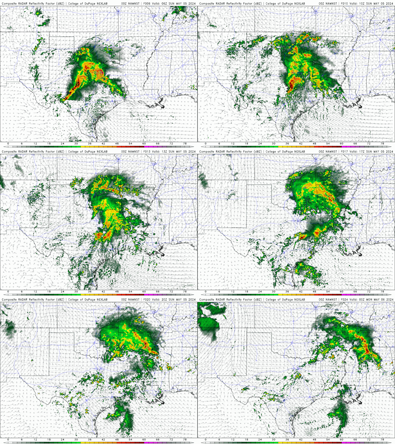
 10:10 PM CDT | May 4, 2024 - A system impacting Texas right now will bring more widespread rainfall to Oklahoma overnight. The risk for severe weather is very low, but isolated instances of hail and wind are possible. The tornado risk is very low. I have attached a loop from one of this evening's weather models, which shows the simulated radar from 1:00 AM to 7:00 PM Sunday. Keep in mind that this is just a weather model and that it is only to give you an idea of what will unfold. Don't get too focused in on the exact locations. :) Attention then shifts quickly to Monday's (potentially) Significant Severe Weather Outbreak. If you read last night's discussion, you will remember that I stated it was likely that the Enhanced Risk would be adjusted southward in later outlooks. They did just that early this morning. You can see the latest outlook below. I would not be surprised to see parts of Northern and Central Oklahoma upgraded to a Moderate Risk in later outlooks. The ...

2024/05/03 - Additional Flooding & Isolated Severe Through Weekend

Image
 9:40 PM CDT | May 3, 2024 - An active weather pattern will continue across the Southern Plains through the weekend. There is a Flood Watch in effect for a good portion of Oklahoma. The Weather Prediction Center is forecasting widespread rainfall amounts of .50-2.00" occurring through Sunday evening. Isolated higher amounts in the 3.00 to 4.00" range is likely with areas that see heavier storms. Isolated severe storms are expected during this period as well. I am not anticipating anything significant through Sunday, though. Hail and wind will be the main hazards, but a Tornado or two is possible. Eyes then turn to Monday, which could be a significant severe weather day from Oklahoma through Nebraska. The SPC currently has a Slight Risk across most of the state with an Enhanced Risk for parts of North Central Oklahoma. There is disagreement with the model guidance, mainly in regards to the cap strength and storm coverage with southward extent. My gut feeling is that, with plen...